ARV
Arealregnskap og planvask
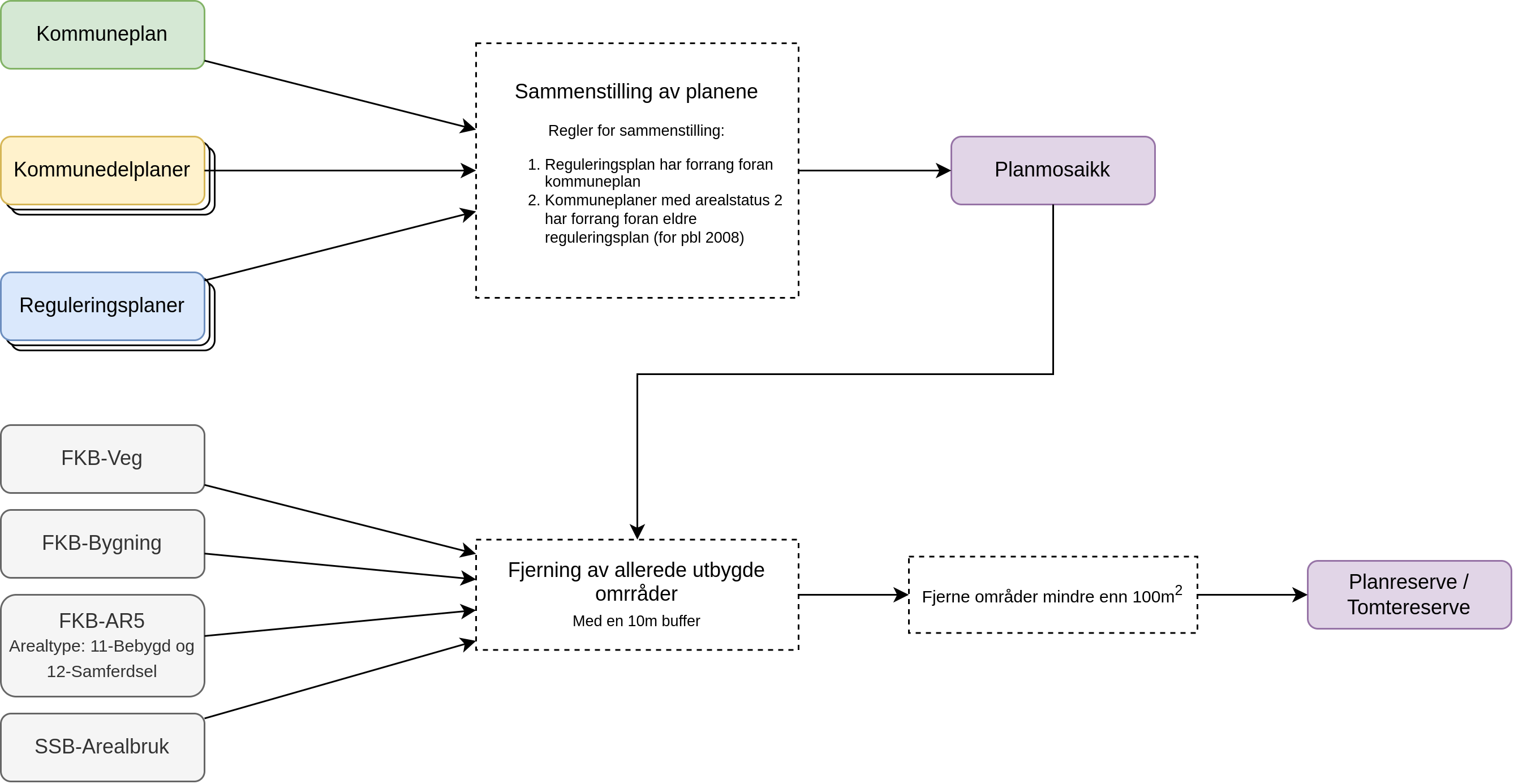
ARV er et operativt og fleksibelt verktøy utviklet spesielt for kommuner, private aktører og organisasjoner som ønsker raskere, bedre og mer bærekraftige beslutninger i arealplanleggingen. ARV analyserer seg frem til arealreserven (planlagt utbyggingsområde som ikke enda er utbygget) basert på dine plankart og utbyggingsdata fra kartverket. Dette grunnlaget analyseres opp mot en lang rekke datakilder for å identifisere potensielle arealkonflikter som ARV gir deg kart og tall for.
Hvem kan bruke ARV?
Offentlige aktører (Kommuner og fylkeskommuner)
- Effektivisér planarbeidet gjennom automatisk «planvask», som systematisk kontrollerer kommunale planer mot nasjonale og regionale føringer og interesseområder.
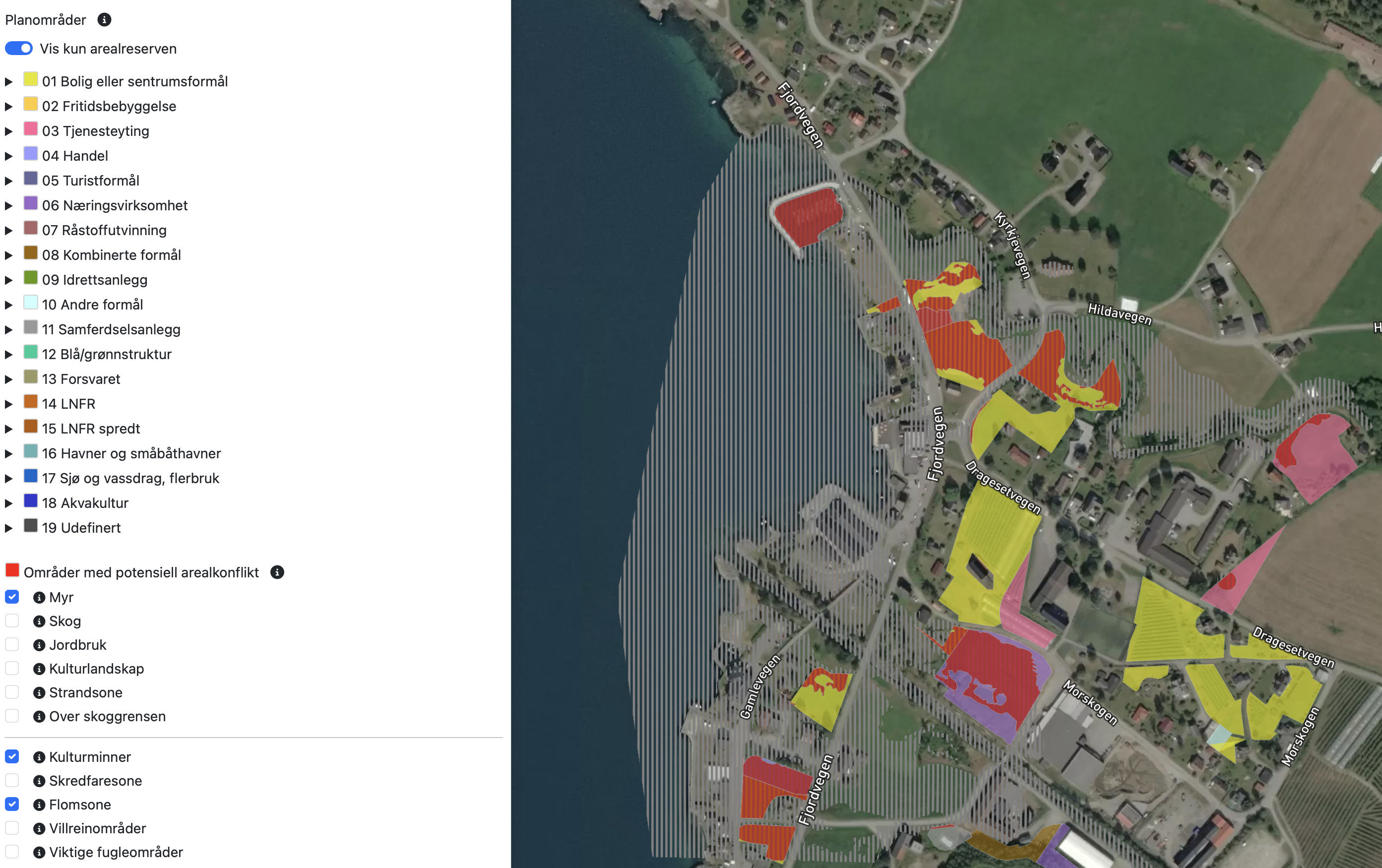
- Identifiser raskt behov for konsekvensutredninger ved å avdekke potensielle konflikter som rasfare, myrer, flomområder og lignende.
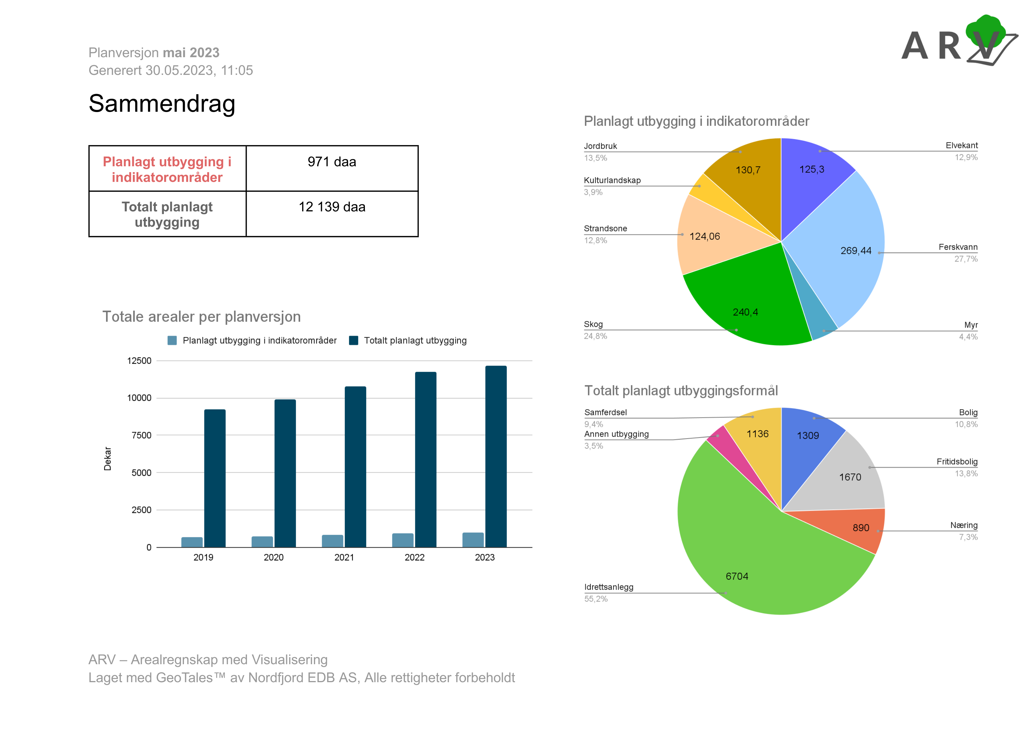
- Utarbeide fullstendige og presise arealregnskaper som oppfyller kravene i Kommunal- og distriktsdepartementets veileder.
Private aktører (Plankonsulenter og utbyggere)
- Spar betydelig tid og ressurser ved tidlig identifisering av potensielle konfliktområder i regulerings- og kommuneplaner.
- Reduser risiko for forsinkelser ved å tidlig avklare behov for justeringer og ytterligere utredninger.
Miljøvernorganisasjoner og NGOer
- Bruk ARV som et verktøy for å overvåke planlagte arealendringer og raskt identifisere potensielle trusler mot naturverdier.
- Understøtt argumentasjon og dokumentasjon i høringsprosesser med faktabaserte analyser.
Hva kan ARV gjøre for deg?
- Arealregnskap
-
ARV produserer arealregnskap basert på kommuners planer eller utbyggeres private planer, og oppfyller
KDDs veileder for arealregnskap i kommuner. - Planvask
- Automatisk identifisering av planer som bør revideres eller justeres etter nasjonale og regionale føringer.
- Konfliktanalyse
- Automatisk beregning av konflikter mellom planlagt utbygging og viktige natur- og miljøinteresser, samt kartlegging av reguleringsrisiko for private.
- Klimagassberegninger
- Integrert modul som beregner klimagassutslipp fra arealbruksendringer basert på offisielle metoder fra Miljødirektoratet.
- Fullstendige rapporter
- Automatisk genererte arealregnskapsrapporter klare til bruk i beslutningsprosesser.
- Offentlig fremvisning
- Muligheten til å dele dine ARV-kart i en fremvisning egnet for offentligheten.
Enkel i bruk: Alt du trenger er å laste opp planene – ARV gjør resten
Eksempler fra ARV
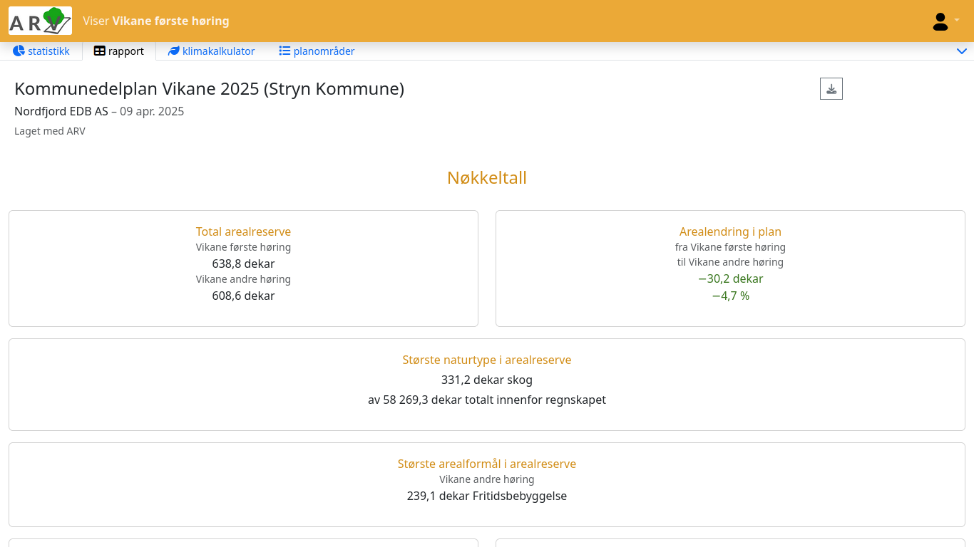
Se eksempel-rapport fra Stryn kommune her.
ARV kan fremstille kart-data på bestilling
Utforsk kart over landsdekkende planlagte utbyggingsområder i kommunenes planer.
Se eksempel fra forskningsrapport med NINA hvor ARV ble brukt til å fremstille resultatene
ARV oppfyller "6.2.2 Utred klimagassutslipp fra arealbeslag" fra M-1941 | Konsekvensutredning av klimagassutslipp
Bør en kommune lage arealregnskap?
| Myndighetenes forventning | Formulering om arealregnskap | Hvem rettes det mot? |
|---|---|---|
| Statlige planretningslinjer for klima og energi (fastsatt 20. des 2024) | «Det bør utarbeides arealregnskap som del av kunnskapsgrunnlaget i kommuneplanarbeidet.» | Kommunene (som planmyndighet) |
| Veileder «Arealregnskap i kommuneplan» (KDD, 2023) | «Kommunal- og distriktsdepartementet anbefaler at kommunene utarbeider et arealregnskap som del av kommuneplanarbeidet.» | Kommunene (generelt) |
| Statsforvalter-brev/forventningsbrev (flere fylker, 2021–25) | Statsforvalteren «forventer at kommuner som vil ta i bruk nye utbyggingsarealer kan legge fram et arealregnskap». | Kommunene (i plan- og byggesaker) |
Ønsker du å lære mer om hvordan ARV kan støtte ditt arbeid?
Book en demo
Ta kontakt med oss for en uforpliktende demonstrasjon og samtale!